Trail Walking La Roche-sur-Foron - TOUR DE LA ROCHE-SUR-FORON - Photo
 COMAN
COMAN

User

© OpenStreetMap contributors
Length
Length
4.6 km
Max alt
Max alt
585 m
Uphill gradient
Uphill gradient
111 m
Km-Effort
Km-Effort  
6.1 km
Min alt
Min alt
522 m
Downhill gradient
Downhill gradient
110 m
Boucle
Boucle
Yes
Creation date :
2014-12-10 00:00:00.0
Updated on :
2014-12-10 00:00:00.0

(0 Reviews)

Walking
Walking
2h00
Difficulty : Very easy

Scan this QR Code to open this trail in the SityTrail application

FREE GPS app for hiking

Logo SityTrail SityTrail

IGN / Geographical institutes

Download SityTrail from the App Store Download SityTrail from Google Play

Logo SityTrail SityTrail World

The world is yours!

Download SityTrail from the App Store Download SityTrail from Google Play Download SityTrail on Huawei AppGallery

About

Trail Walking of 4.6 km to be discovered at Auvergne-Rhône-Alpes, Upper Savoy, La Roche-sur-Foron. This trail is proposed by COMAN.

Description

Découverte du Château  jusqu’à la bénite fontaine en passant dans les méandres de la ville

Elevation profile

Positioning

Country:
France
Region :
Auvergne-Rhône-Alpes
Department/Province :
Upper Savoy
Municipality :
La Roche-sur-Foron
Location:
Unknown
Start:(UTM)
292257 ; 5104672 (32T) N.

Trails nearby

Trail Walking La Roche-sur-Foron - 74 roche parnal 05.08.2022 - Photo
Walking
GUIDE
randodyssée

Walking

Medium
La Roche-sur-Foron, Auvergne-Rhône-Alpes, Upper Savoy, France
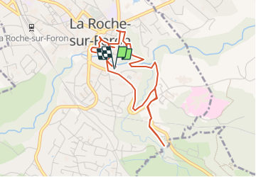
9.5 km | 20 km-effort
6h 23min
Yes
Trail Walking La Roche-sur-Foron - sur cou par a grotte face ouest - Photo
Walking
GUIDE
nadd73

Walking

Difficult
La Roche-sur-Foron, Auvergne-Rhône-Alpes, Upper Savoy, France
7 km | 16 km-effort
4h 29min
Yes
Trail Walking La Roche-sur-Foron - Tour de Sur Cou - Photo
Walking
christophe7406

Walking

Medium
(1)
La Roche-sur-Foron, Auvergne-Rhône-Alpes, Upper Savoy, France
6.9 km | 15.1 km-effort
3h 0min
Yes
Trail Walking La Roche-sur-Foron - sur cou - Photo
Walking
alexdigit

Walking

Easy
(1)
La Roche-sur-Foron, Auvergne-Rhône-Alpes, Upper Savoy, France
3.4 km | 7.8 km-effort
1h 19min
No
Trail Walking La Roche-sur-Foron - GLIERES / BORNES: COL DU COU - CHALET DE BALME - Photo
Walking
djeepee74

Walking

Easy
La Roche-sur-Foron, Auvergne-Rhône-Alpes, Upper Savoy, France
7.1 km | 13 km-effort
3h 2min
Yes
Trail Walking La Roche-sur-Foron - 2021-09-22_09h20m43_activity_7510877141 - Photo
Walking
djeepee74

Walking

Very difficult
La Roche-sur-Foron, Auvergne-Rhône-Alpes, Upper Savoy, France
12 km | 24 km-effort
5h 33min
Yes
Trail Walking La Roche-sur-Foron - GLIERES / BORNES: LE CHENET - SUR COU - COL DU FREU - ROCHE PARNAL - COL DU CABLE - BALME - Photo
Walking
djeepee74

Walking

Difficult
La Roche-sur-Foron, Auvergne-Rhône-Alpes, Upper Savoy, France
10.4 km | 23 km-effort
5h 15min
Yes
Trail Walking Saint-Laurent - Moussy - Le Pacheux - Passage de la Cache - Photo
Walking
GUIDE
Kargil

Walking

Medium
Saint-Laurent, Auvergne-Rhône-Alpes, Upper Savoy, France
10.4 km | 21 km-effort
3h 35min
Yes
Trail Walking La Roche-sur-Foron - GLIERES / BORNES: LE CHESNET - SUR COU - COL DU FREU - Photo
Walking
djeepee74

Walking

Medium
La Roche-sur-Foron, Auvergne-Rhône-Alpes, Upper Savoy, France
11.9 km | 23 km-effort
4h 30min
Yes


Close
My subscriptions